
FSO/DE Atmospheric Station
All-Sky Infrared + Visible Imaging with Day/Night Turbulence Monitoring
One Station. The Whole Sky. Day and Night.
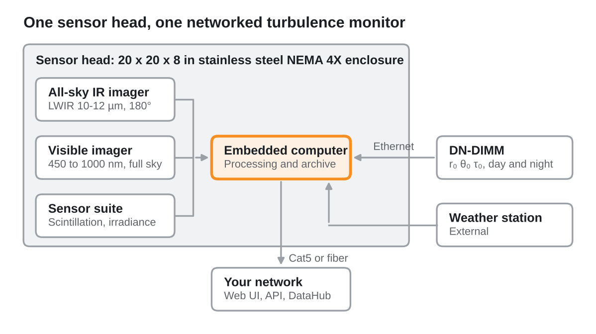
The Solmirus FSO/DE Atmospheric Station is a turnkey atmospheric solution built for laser communications. We have fused the proven ASIVA/ASIS calibrated infrared channel with the Miratlas all-sky visible system into a single integrated imaging and control unit, then networked it with the DN-DIMM turbulence monitor and an external weather station. The result: every parameter that decides free-space optical link availability (cloud cover, cloud opacity, turbulence r0, θ0 and τ0, absorption, irradiance and weather) measured continuously, 24/7/365, from one install.
Infrared sees what the eye cannot. The Solmirus ASIVA/ASIS channel detects cloud at night, through haze and in full daylight, calibrated to absolute radiance and backed by 20+ years of all-sky infrared field experience. Visible adds the full picture. The Miratlas Sky Monitor imager and sensor suite are proven at more than 60 stations in 20 countries. Turbulence, around the clock. The DN-DIMM takes the reference technique used to qualify the world's largest telescope sites into daylight, so turbulence is tracked continuously with no handover at dawn or dusk.
One enclosure, one controller, one data interface. Install it, connect your network, and know your sky before your link does.
SkyVIS: Every Sector, Link-Ready
The visible channel does more than take pictures. Miratlas SkyVIS turns every all-sky frame into a link decision: at night it matches thousands of catalog stars across the sky, measures how many are actually seen and how faint they go, and converts that into per-sector availability and an estimated attenuation at 1550 nm. By day it publishes clear-sky fraction, so the record runs unbroken through dawn and dusk. Fed into SOLUS alongside the calibrated infrared channel, it gives operators both cloud presence and optical loss for every direction they might point.
32 Sky Sectors
8 azimuths × 4 elevation bands from 15° to zenith, each classified on every pose, day and night.
Availability (T)
Fraction of expected stars actually detected in each sector: a direct, measured view of where the sky is open.
Depth & A1550
Limiting magnitude per sector, converted to an upper-bound attenuation in dB at the 1550 nm FSO band.
Link Class A to D
Each sector graded from nominal link to do-not-point, ready for station selection and handover planning.
| Class | Availability T | Depth M | A1550 | Link |
| A | ≥ 80 % | ≥ 5.0 | ≤ 2 dB | Nominal |
| B | ≥ 80 % | 4.0 to 5.0 | ≤ 6 dB | Open with margin; provision the loss |
| C | ≥ 80 % | < 4.0 | > 6 dB | Degraded |
| B′ / C′ | 30 to 80 % | as A / B | as A / B | Broken cloud; intermittent |
| D | < 30 % | any | out of budget | Unavailable; do not point |
Example: Observatoire de Haute-Provence, April 2026. Class A in 82 % of night sector-poses, 96 % median night transmission. → Explore the live SkyVIS demo
SOLUS: From Sky to Link Verdict
The station runs SOLUS, the Solmirus Unified Software behind the ASIVA and ASIS line. Every cycle it acquires, references against the onboard blackbody, and turns calibrated infrared radiance into cloud mask, optical depth, brightness temperature and precipitable water vapor. Then it does what an operator actually needs: it answers go, marginal or no-go for the direction you are pointing, and forecasts the next few minutes.
One Authoritative Link Status
Infrared and visible are not two dashboards to reconcile. SOLUS fuses them into a single link status: calibrated infrared cloud mask and optical depth, SkyVIS star-count transmission and estimated 1550 nm attenuation, DN-DIMM turbulence and the weather station, all evaluated together on your line of sight. Each sensor covers the others' blind spots: infrared sees cloud in the dark and in daylight, the visible channel measures actual optical loss against the stars. The result is one definitive answer per direction, with every contributing measurement and threshold listed behind it, and one API to ask it from.
Link Verdict
Go / marginal / no-go against your own thresholds: cloud optical depth, sky temperature, seeing, r0, scintillation, transparency, PWV, wind, humidity, rain rate and solar separation.
Line of Sight
Give it an altitude and azimuth and it samples cloud on that exact path, scales turbulence by airmass and checks distance from the Sun.
Sky Nowcast
Short-range cloud forecast by sky zone and lead time, for fixed links or satellites propagated from their TLEs.
Honest Data
Stale or missing data grades unknown, never go. Every verdict lists the parameters that drove it, and PWV carries its own provenance.
Infrared Measurements
| Measurement | What it is | Why it matters for FSO |
| Calibrated Radiance | Sky radiance normalized against an onboard blackbody reference, per pixel, across the full 180° sky. | The traceable base every other product is built on. Comparable across sites, seasons and years. |
| Cloud Mask | Cloud left after the modeled clear sky is removed, thresholded to cloud / no cloud. | Sees cloud day and night, including thin and high cloud visible cameras miss in the dark. |
| Optical Depth | How strongly cloud attenuates, per pixel. | The difference between a link that is veiled and one that is blocked. Drives the go / marginal / no-go verdict. |
| Sky Cover | Percentage of sky covered, overall and in any user-defined field of view. | Station availability statistics and site comparison, from a single number per frame. |
| Brightness Temperature | Apparent sky and cloud temperature in kelvin, per pixel. | Separates warm low cloud from cold cirrus and tracks how the atmosphere is changing over the station. |
| Precipitable Water Vapor | Column water vapor fitted against an atmospheric model, with a provenance flag on every value. | Water vapor absorbs in the infrared; PWV tells you how much path loss to budget before a single cloud appears. |
Full API Included
Every measurement, image and control in SOLUS is available through a documented HTTPS / JSON API, included with every station: live and historical data, calibrated images, link verdicts, nowcasts, sensor readings, run control and configuration. Drop the station straight into your ground station scheduler, network operations center or data pipeline. Each unit serves its own live API documentation.
Data as JSON; images as FITS, NetCDF, TIFF, PNG or JPG.
Built for Government & Defense
The station can be delivered STIG hardened for government and defense deployments. SOLUS already runs HTTPS-only with role-based accounts, a 15-character password policy with history and expiration, account lockout, inactivity timeouts, a sign-in audit log and a per-unit API key, built for closed and controlled networks.
Data Products & Measurements
24/7 Cloud Detection
Calibrated LWIR cloud mask, cloud cover and optical depth, day and night, in all weather.
Day & Night Turbulence
Fried parameter r0, isoplanatic angle θ0 and coherence time τ0 from one technique, with no handover at dawn or dusk.
Visible All-Sky Imagery
450 to 1000 nm full-sky imaging for daytime cloud cover and nighttime transparency.
Absorption & Weather
Total water column, irradiance, downwelling longwave and full surface weather.
→ More on FSO & Directed Energy
Technical Specifications
| IR Sensor | 640 × 480 uncooled LWIR microbolometer, 10 to 12 µm filter |
| IR Lens | Proprietary coated Solmirus LWIR fisheye, 180° FOV |
| IR Calibration | Absolute radiometric calibration; motorized hatch with integrated blackbody reference |
| Visible Imager | 450 to 1000 nm, full sky, GigE |
| Sensors | Sun Scintillation Sensor, pyrgeometer, irradiance, total water column |
| Weather Station | External station connected to the sensor head: temperature, pressure, humidity, wind, rain and rain rate; no moving parts |
| DN-DIMM | Two 80 mm telescopes, 200 mm apart; 1 ms exposures at 400 fps; one measurement every 30 s; r0, θ0, τ0 at 550 nm, zenith-normalized |
| Cadence | IR ≤ 30 s; turbulence 30 s |
| Enclosure | Sensor head: 20 × 20 × 8 in stainless steel NEMA 4X enclosure (Adalet), powder-coated; thermoelectric cooling |
| Processing | Embedded control computer; on-board processing and raw data archiving |
| Interface | Ethernet (fiber / Cat5); web UI; REST API; optional Miratlas DataHub |
System Options
- SHABAR daytime Cn² profiling, 0 to 1,000 m
- C-DIMM in place of DN-DIMM
- Application-specific IR filters
- Precipitation sensor
- Large capacity storage options
- DataHub & Lamarck dataset access
- LaserCom Pathfinder site analysis
- STIG-hardened configuration for Gov / Defense
- Training / Installation / Maintenance plans
Applications
- Optical ground station site survey
- Live FSO / laser comm link operations
- Directed energy & defense optics
- Quantum communication ground stations
- Telescope sites
- Atmospheric & meteorological stations
Ready to learn more about the FSO/DE Atmospheric Station?
Developed with Miratlas SAS. Download the datasheet or contact us to discuss specifications and pricing.