
Atmospheric Science Research
Research-quality all-sky measurements of sky cover, spectral radiance, cloud temperature, cloud height, and optical depth.
Atmospheric & Climate Research
Solmirus works closely with atmospheric and climate scientists to provide instrumentation tailored to their data acquisition and research needs — delivering continuous, calibrated, measurement-grade sky imagery and data products around the clock.
The ASIVA and ASIS instruments are automatic, continuously operating digital imaging systems designed to capture infrared and visible hemispheric sky images. The software automatically identifies cloudy and clear regions at user-defined intervals and calculates sky cover and sky quality — providing a real-time display of current sky conditions.
The instruments provide a full 180° hemispheric view of the sky and are designed for continuous operation in harsh field environments — making them well suited for long-duration deployments at remote research sites.
ASIVA all-sky IR imagery — continuous hemispheric sky monitoring for atmospheric research
Notable Capabilities for Atmospheric Scientists
All-Sky IR Imaging
Full hemispheric infrared viewing using Solmirus' proprietary fisheye lens system — capturing the complete sky dome in a single frame.
Calibrated Spectral Radiance
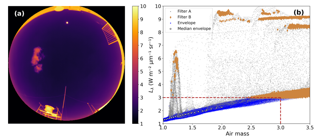
Unique hatch system providing calibrated spectral radiance images — yielding unparalleled accuracy in clear-sky identification, cloud identification, and sky/cloud radiance measurement.
Precipitable Water Vapor
PWV calculated with respect to relevant MODTRAN simulations — a critical parameter for atmospheric modeling and radiative transfer studies.
Sky Cover Reporting
Automated sky cover percentage reporting at user-defined intervals with real-time display via a web-based user interface.
Cloud Temperature & Height
Cloud temperature measurement (brightness and color temperature) and cloud height determination using ancillary data from the operational site.
Raw Data Archive
All raw imagery and data can be saved for complete post-processing analysis — supporting long-term climate studies and retrospective research.
Interested in our atmospheric research instruments?
Contact us to discuss your research requirements or request instrument specifications.
Inquiry Form
Tell us about your FSO or atmospheric sensing project. Please complete the form below and a member of our team will respond within 1–2 business days.
Inquiry Submitted
Thank you — your project inquiry has been received. A member of the Solmirus team will be in touch shortly.